Official Project Status Notice — September 21, 2026

Re: Timeline Suspension & Hardware Gating Metrics

Notice is hereby given that all physical field validation operations and upcoming development phases for the 1:1 scale Marconi Wireless Towers reconstruction at Wellfleet, MA, Cape Cod, are placed on hold.

Following the completion of over $3,000,000 in resilient community, public safety, and maritime software applications, this platform has received zero reasonable interest from potential end-users.

While our underlying near-geospatial routing loops, Haversine math, and tripod-stabilized orientation data-smoothing code are mathematically finalized under core commit 86d9474, further field validation and retail hardware deployment are suspended until institutional B2B procurement allocations or hardware pipeline sponsorships are secured by external entities.

The core software technology remains fully compiled, active, and indexed — becoming finalized now as an unassailable wall of permanent public prior art.
Persistent Digital Ledger
Ground Truth
Immutable property history records for municipal verification and insurance claims.
Flood & Disaster Response
Ground Truth
Activates immediately when the grid goes down - first responder property intelligence, flood zone mapping, and offline mesh continuity.
USPS Mobile Mesh
Ground Truth
Postal carrier network integration for real-time address validation and delivery corridor mapping.
NARA Archival Bridge
Ground Truth
National Archives connection for historical property records and civic documentation.
MARA AR/MR Interface
Ground Truth
Augmented reality overlay for on-site property inspection and trade verification.
eVTOL Flight Corridors
Ground Truth
Air mobility pathways coordinated with property infrastructure and rooftop access points.
Humanoid Semantic Mapping
Ground Truth
AI-assisted navigation data for autonomous systems and accessibility routing.
Minuteman Doctrine (250th)
Ground Truth
Patriots Path civic education framework aligned with America 250 commemoration.
Virtual Mailbox (UNM)
Ground Truth
Universal Neighborhood Mailbox - Santa Cruz pilot for digital-physical address unification.
MESA Habitat Audit
Ground Truth
Environmental sustainability assessment for residential and commercial properties.
IDR Infrastructure Debt Recovery
Ground Truth
Municipal finance tracking for infrastructure improvements and assessment bonds.
fp NGT Data Engine:LIVE
Back to AR Property
Hardware-Neutral · BYOG

folio-pin AR Mapping for Smart Glasses

Subscribe to folio-pin's patent-pending AR mapping software and use it with compatible hardware you already own. Bring your own glasses; open capability detection supplies the spatial experience without manufacturer-specific application code.

Every overlay is anchored to a coordinate-locked data "bin"—a fixed real-world latitude/longitude/elevation point that holds the content tied to that spot, independent of any one headset. Because the bin itself is device-agnostic, folio-pin can stand up a working application for a new AR device the moment it exposes standard WebXR capabilities, without rebuilding the underlying map data.

Hardware-neutral AR development

folio-pin uses the open WebXR Device API and runtime capability detection instead of separate code paths for individual manufacturers. Compatible devices receive the same standards-based interface, with location-assisted and simulated fallbacks when immersive AR is unavailable.

The coordinate-locked data bins that hold each overlay's content are what make this possible: the bin, not the headset, owns the content, so a new cutting-edge device only needs to speak WebXR to read the same bins every other compatible device already uses.

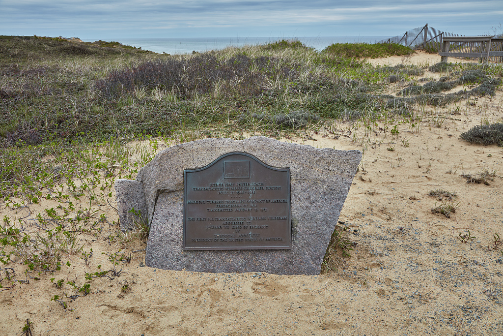
Bronze plaque marking the Marconi Wireless Station site in South Wellfleet, Massachusetts, on Cape Cod
Field-verified bin

A real coordinate-locked bin: the Marconi Wireless Station Site

Instead of a hypothetical example, this bin is anchored to an actual, citable location — the site in South Wellfleet, Massachusetts, within Cape Cod National Seashore, where Guglielmo Marconi sent the first U.S. transatlantic wireless message to King Edward VII on January 18, 1903. No structures remain on site today; the bin is what lets a compatible device overlay the station's history on the empty ground.

41°54'50"N, 69°58'16"W· South Wellfleet, MA

Photograph: Carol M. Highsmith, 2019 · Library of Congress Prints & Photographs Division · LC-DIG-highsm-57429 · No known restrictions on publication. The bin pulls federally-held historic imagery through the Library of Congress's public API — the same working pipeline folio-pin's History Map already uses — because the National Archives' own catalog is a browser application without a server-callable endpoint.

View source record at loc.gov

Below is what this bin actually produces on a device today: a live check of whether your browser supports a camera-tracked WebXR session, plus an honest fallback — a compass-and-distance HUD, not a simulated overlay — when it doesn't.

Location-assisted mode
checking…

This device has no WebXR immersive-ar session support (or none was detected). What follows is a directional aid, not a camera-locked overlay: it points toward the Marconi site and estimates distance from GPS, without tracking the physical terrain.

N

Bearing to site

Share your location to see live distance and bearing to the Marconi Wireless Station Site.

41°54'50"N, 69°58'16"W · South Wellfleet, MA

Bearing and distance are computed on-device from your GPS fix and orientation sensor — no server round-trip required once location access is granted. If connectivity drops after that point, this reading keeps working; it does not, however, make the AR overlay itself work offline on hardware that lacks WebXR support.

This HUD can be mirrored onto standard display glasses today using a USB-C cable that supports DisplayPort Alt Mode — the same mirroring most phones already use to drive an external monitor. No app changes are needed for that part; the glasses simply need to accept DP Alt Mode video-in.

Drive HUD Companion

Same compass-and-distance math, mounted on your dashboard

Mount a phone in a fixed dashboard cradle and it runs the same Haversine-distance and compass-heading math shown above, aimed at your route's next waypoint instead of a historic bin. If your glasses support display mirroring (screen casting or a wired video-out mode), the phone can mirror that HUD to the lenses. That is the entire mechanism — a bearing arrow and a distance readout, refreshed from the phone's own GPS and compass sensors.

Primary use — connected: with a live connection, the route, waypoints, and any live traffic or hazard data refresh continuously, so the heading and distance readout stays current for the whole trip. This is the normal, expected operating mode.
Secondary benefit — offline tolerance: once a route is loaded, the same math keeps producing heading and distance through brief cellular dead zones. It is a resilience fallback, not the main reason to use it.

This is a compass-and-distance overlay, not camera-based spatial anchoring, and it does not paint lane-accurate graphics onto the road or replace turn-by-turn map guidance. It still requires a GPS fix — GPS is a satellite service, so this software does not remove that dependency, and no software can make a GPS receiver jam-proof. Full AR anchoring (content that visually locks to a specific object or lane on the road) requires the glasses' own camera/SLAM hardware, which this software does not provide or claim to provide.

Free tactical tierSoftware only · BYOG

Weather Diagnostic · $0

Open-source AR diagnostics for weather professionals

A direct Folio-Pin offer for NOAA professionals, American Meteorological Society members, and qualifying broadcast weather centers to evaluate near-geospatial information through compatible smart glasses.

  • Near-geospatial weather and incident overlays
  • Field annotations and saved diagnostic views
  • Exportable findings for internal review
  • Structured feedback and diagnostic reporting
Apply for free access

Application required

Request Weather Diagnostic access

Tell us who will test the software, which compatible glasses you will provide, and the meteorological or broadcast workflow you want to diagnose. No payment information is collected.

Billing setup pending. Pricing below is final, but secure subscription enrollment is not yet available. You cannot be charged right now. Enrollment will open once payment processing is connected.

Pre-register interest

Be first in line when enrollment opens

Secure billing isn't connected yet, so no payment is collected now. Pre-register your interest and we'll email you the moment your chosen tier is open for subscription.

Individual Explorer

For homeowners, hobbyists, and single-property AR visualization.

$12/month
  • Patent-pending folio-pin AR map anchoring
  • 1 active property or project
  • Compatible WebXR display support
  • Standard spatial anchor library
  • Offline anchor caching
  • Community support
Most Popular

Field Professional

For contractors, sign painters, inspectors, and real-estate pros.

$29/month
  • Everything in Individual Explorer
  • Up to 25 active properties or projects
  • High-precision anchor placement
  • Measurement & overlay tools
  • Shareable client AR walkthroughs
  • Priority email support

Organization

For agencies, municipalities, and multi-user teams.

$99/month
  • Everything in Field Professional
  • Unlimited properties or projects
  • Up to 10 team seats
  • Shared anchor collections
  • Usage analytics dashboard
  • Dedicated onboarding
Tourism & Outdoors

Tourism Experience

For destinations, heritage trails, visitor bureaus, and guided outdoor experiences.

$4.99/month
  • Everything in Organization
  • Location-linked visitor experiences
  • Tour, trail, and landmark collections
  • Branded AR wayfinding overlays
  • Seasonal content publishing
  • Visitor engagement analytics

Fleet / Enterprise

For large deployments, custom SDK access, and volume seats.

Custom
  • Everything in Organization
  • Custom seat volume
  • Advanced WebXR integration
  • Custom spatial pipelines
  • SLA & security review
  • Direct engineering contact

Drive HUD Companion

Dashboard-mounted heading & distance HUD, mirrored to compatible display glasses.

$9/month
  • Bearing + distance to your next waypoint
  • Haversine-based distance, live compass heading
  • Route cached locally — tolerant of cellular dead zones
  • Mirrors to glasses that support display mirroring
  • Not lane-level AR paint-on-road guidance
  • Requires a GPS fix; not a satellite-free system
Manufacturer & brand licenseProposed program

A certified-device license for smart-glasses manufacturers

Individuals and professionals subscribe above. Manufacturers and brands license at the device-family level instead: one annual agreement that lists their approved glasses on folio-pin's certified-device directory and covers their end-user base for the browser-native PWA and offline anchor cache.

Gate 1 · Baseline license

$5,000,000/ year

A flat annual license fee for every approved manufacturer or brand. It authorizes their device families on the certified-device directory and extends the license to their global end-user base.

Gate 2 // Annual subscription-growth escalator

Scales with the subscriptions we add

At the close of each active fiscal cycle, the baseline license fee scales upward by a percentage indexed to the growth in folio-pin subscriptions activated on that manufacturer's certified devices. Only folio-pin's own contribution is measured. The manufacturer's existing hardware market, shipments, and sales are never part of the calculation.

Sovereign Terms: This baseline license fee is an absolute, non-negotiable operational gate. No hardware profile, firmware container, or micro-display architecture from Meta, Google, XREAL, RayNeo, or Viture is authorized to handshake with the NGTlink ground mesh or utilize our edge-stabilized spatial visualization core until this annual institutional fee is executed and cleared directly into our secure registry. BYOG retail subscribers remain strictly bound to the standalone consumer telemetry terms above.

Discuss a manufacturer license

Open WebXR Compatibility

folio-pin checks browser and device capabilities at runtime. Confirm these requirements before subscribing.

WebXR-capable display

Capability detected

The browser checks immersive AR support at runtime without relying on a manufacturer-specific branch.

Compatible browser host

Host required

A secure-context browser host provides WebXR, location, and orientation capabilities when available.

Open spatial features

Runtime dependent

Anchoring and interaction adapt to standards-based capabilities reported by the current device.

Graceful fallback

Built in

Location-assisted and simulated 3D views remain available when immersive WebXR is unavailable.

What Your Subscription Includes

Patent-Pending AR Mapping

folio-pin's proprietary location-linked AR anchoring, available today.

Spatial Anchor Library

Place, save, and revisit AR content tied to real-world coordinates.

Data Stays Yours

Your anchors and property data remain under your account control.

Standards-First Experience

Uses WebXR capability detection with location-assisted and simulated fallbacks.

Bring Your Own Glasses (BYOG)

folio-pin provides software only. You obtain compatible glasses and any required host device separately. folio-pin does not sell, lease, ship, warranty, insure, or provide technical support for hardware. Please confirm browser and device capabilities before you subscribe.

Subscription FAQ

Is the free Weather Diagnostic tier a NOAA or AMS program?

No. It is a direct Folio-Pin software offer for NOAA professionals, AMS members, and qualifying broadcast weather centers. NOAA and the American Meteorological Society do not sponsor or endorse it. Access is application-based, software-only, and intended for non-operational evaluation.

Do I buy glasses from folio-pin?

No. folio-pin is a bring-your-own-glasses (BYOG) software subscription. You obtain compatible hardware separately; folio-pin does not sell, lease, ship, warranty, or support hardware.

Which devices work?

Compatibility is determined at runtime through open WebXR browser capabilities rather than a device-name list. Confirm immersive AR, secure-context, location, and orientation support on your intended browser host before subscribing.

What happens when immersive WebXR is unavailable?

The experience falls back to location-assisted or simulated 3D modes instead of loading manufacturer-specific code.

Is there a license for smart-glasses manufacturers and brands?

Yes, as a proposed program. A manufacturer or brand license is a flat $5,000,000 per year with an annual adjustment tied to growth in folio-pin subscriptions on that manufacturer's certified devices, never to the manufacturer's own hardware sales. It is separate from the consumer and professional subscriptions above, and terms are only final once set out in a signed agreement. Contact us to discuss it.

When can I subscribe?

Pricing is published now. Secure billing is being finalized, so enrollment is temporarily unavailable. Plans will open for subscription once billing setup is complete.

Employment projectionNot yet measured

Offline field capture on a phone and a fixed stand.

Field operators use standard smartphones on fixed stands to project 1:1 history wireframes onto the physical landscape without relying on cloud connectivity. If AR glasses makers fund the hardware, this scales into a larger field-capture workforce.

  • Field capture operators
  • Spatial survey technicians
  • Wireframe review and quality specialists

Depends on AR glasses industry validation and hardware funding.

Directional projection only. No jobs have been counted yet, and no wage or headcount figures are promised.